[Home]
[Soil Washing Study Index] [Next Section]
Soil Washing Treatability Study for SWMU B-20
Section 2 - Site and Study Background
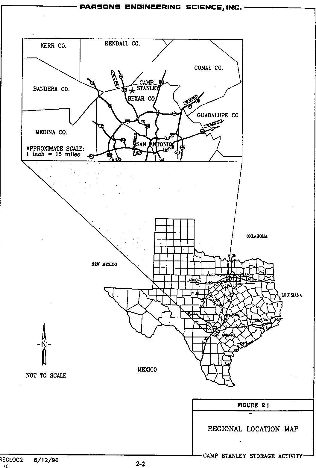
CSSA is located in northwestern Bexar County, approximately 19 miles northwest of downtown San Antonio in south-central Texas (Figure 2.1). The installation consists of 4,004 acres immediately east of State Highway 3351 (Ralph Fair Road), and is approximately 0.5 mile east of Interstate Highway 10 (Figure 2.1).
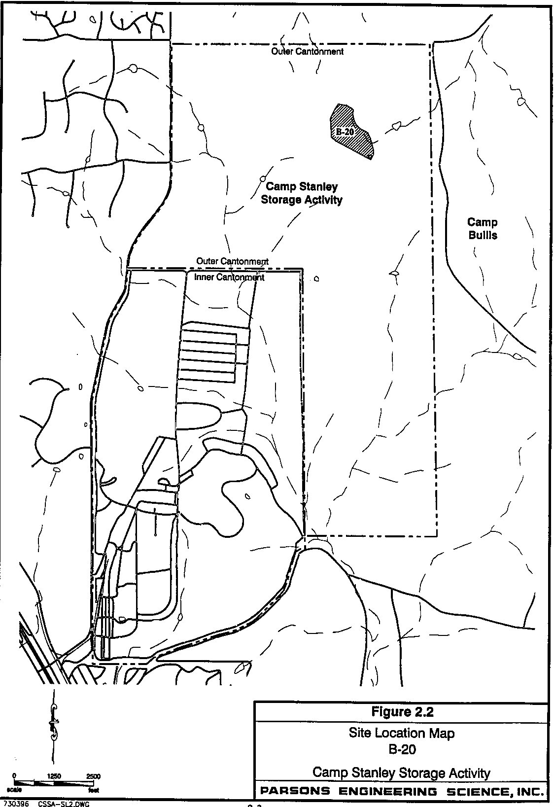
CSSA is a restricted-access installation with inner cantonment lands to the southwest and outer cantonment areas to the east and north. Operation buildings and storage magazines are located within the inner cantonment. Outer cantonment land is primarily undeveloped open range. The eastern boundary of CSSA and part of its northern and southern boundaries are contiguous to Camp Bullis Military Training Reservation. The surrounding area to the west is primarily rural and zoned for residential use. Some residential development is also present west, northwest, and southwest of the installation. The location of SWMU B-20 at CSSA is shown in Figure 2.2.
2.2 Site Background and History
As mentioned in the introduction, the former SWMU B-20 is a 33.5-acre field surrounded by wooded areas in the northeastern portion of CSSA. According to a 1950 memorandum on file at CSSA, approximately 200 tons of ammunition per year were destroyed at the site from 1946 to 1950. Additional explosives were detonated in 1984, 1986, and 1987. There were no reported detonations at the site from 1951 to 1983, in 1985, or after 1987. SWMU B-21 is located adjacent to B-20 and consists of spent ammunition from the practice firing building at CSSA.
According to the U.S. Department of Agriculture (USDA) Soil Conservation Service (SCS) (now the Natural Resource Conservation Service) soil survey for Bexar County, Texas, soil types at the B-20 site include Brackett-Tarrant association, Crawford and Bexar stony soils, and the Krum complex (Kr) (USDA, 1991).
The Brackett-Tarrant association occurs on the hills in the west-central and northern portions of the B-20 site. The Crawford and Bexar stony soils occur in the north-central and southeastern portions of the B-20 site on broad, level to gently undulating areas.
The Krum complex soils are located in infrequently flooded streambeds such as those in the eastern and northeastern areas of B-20. Additional information concerning the soil types at CSSA is included in Soils section of the Background Information Report.
A description of the B-20 geology is included in the Geology section of the Background Information Report.
2.5 Statistical Evaluation of Background Metals Concentrations
Information regarding the statistical approach, normality tests, and procedures for non-detects for background metals concentrations is included in the Statistical Evaluation of Background Metals Concentrations found in Volume 2 of the CSSA Environmental Encyclopedia. The background levels of soil types located at CSSA's B-20 site were used in the evaluation of cleanup and closure criteria.
2.6 Summary of Prior Investigation Results
A brief summary of results obtained from previous investigations can be accessed through B-20 Links. An overview of the results of previous investigations is provided below. A chronology lists environmental investigations at B-20.
A total of 43 surface soil samples were collected during the Phase I Remedial Investigation of B-20 in November 1994. These samples consisted of 21 judgmental samples and 22 random systematic samples. An additional 16 surface soil samples were collected in September 1995 during the Phase II Remedial Investigation. All surface soil samples were collected at a depth of approximately 0.5-foot. Analytical techniques followed procedures described in Test Methods for Evaluating Solid Waste, U.S. EPA, SW-846, November 1986 (USEPA, 1986). Terra Laboratories in League City, Texas performed all metal analyses for the remedial investigations at B-20.
Results of these investigations concluded that approximately 30 percent of the surface soils were contaminated with heavy metals including arsenic, barium, cadmium, lead, and mercury at concentrations above Risk Reduction Standard 1 (RRS1), or background levels (see Table 2.1). Figure 2.3 shows the approximate areas where each metal of concern exceeded standardized background levels. Subsurface soils were generally not contaminated with heavy metals. Sampling locations and tables presenting analytical results are included in Section 4 and Appendix C of the Addendum to Remedial Investigation Report for B-20 (Parsons ES, 1996).
Table 2.1 - Summary of Surface Soil Sampling Results for Heavy Metals
| Contaminant | Phase I Remedial Investigation | Phase II Remedial Investigation | ||
|
| # of Samples Exceeding RRS1 | # of Samples Exceeding RRS2 | # of Samples Exceeding RRS1 | # of Samples Exceeding RRS2 |
| Arsenic | 1/41 | 6/41 | Not Analyzed | Not Analyzed |
| Barium | 5/41 | 0/41 | 4/16 | 0/16 |
| Cadmium | 5/41 | 0/41 | 1/16 | 0/16 |
| Chromium | 0/41 | 0/41 | Not Analyzed | Not Analyzed |
| Lead | 6/41 | 2/41 | 5/16 | 1/16 |
| Mercury | 10/41 | 0/41 | 6/16 | 0/16 |
Explosive residue was detected at low concentrations in extremely localized areas. For instance, soil samples collected immediately under "chunks" of raw TNT contained explosive residue, as might be expected. However, soil samples collected as little as 3 to 4-inches away did not contain any explosives. Because of issues concerning the quality of any data generated from Intertek Testing Services (ITS), the explosives data were determined to be questionable and are not included in Table 2.1. In addition, a total of 812 UXO items were removed from the site and its perimeter areas (Parsons ES, 1996). Most of the UXO found at the site consisted of explosive residue encased in a portion of the original metal housing of the ordnance item. The focus of this report is on the ability of soil washing to remediate heavy metals from surface soils at CSSA and does not address UXO or explosive residue.
During 1997, UXO items were removed from approximately 6 acres of surface soils located in the northern portion of the site. Initially these items were removed during a "mag and flag" UXO identification operation. However, the large amount of buried metallic debris in this portion of the sites made this effort extremely labor intensive. Each individual metallic item identified by a magnetometer had to be flagged and hand-dug. Many of these items were found to be nails and other non-UXO debris. Therefore, in 1997, a sifting operation was initiated to remove the UXO and other metal debris. The top 6 inches of soil in the B-20 site was excavated, stockpiled and sifted in the second phase of the remedial investigation to remove UXO and scrap metal. The sifted soils were then characterized and compared against background RRS1 criteria for lead. These samples were only analyzed for lead because, as shown in Figure 2.3, lead was the only metal in this portion of the site which exceeded background levels. Samples were collected at a rate of one per 500 cubic yards. Analytical results indicate that the sifted soils exceeds background criteria for lead. ITS laboratory analyzed the samples collected during the sifting operations. Because of issues concerning the quality of any data generated from the ITS laboratory, the data were determined to be questionable and only usable as screening or qualifying data. The-ITS qualified data however, complements the existing data collected during the previous phases of remedial investigations, although the lead levels are higher than previously observed.
The results of these investigations indicate that both the sifted soil piles from the northern 6 acres of the site and the approximately 10 acres of soil which remains in-situ in the central portion of the site will require remediation of metals to close under RRS1 (background). Figure 2.3 shows the 10-acre area in the center of the site. The sifted soil piles (approximately 2,500 cubic yards) from the northern 6 acres of the site are currently mounded within the 6-acre area.
2.7 Media and Contaminants of Concern
A discussion of the media and contaminants of concern is located in the B-20 section of Volume 1-2 of the CSSA Environmental Encyclopedia and in the Remedial Investigation Report for SWMU B-20. Results obtained from additional samples taken during the second phase of investigation at B-20 are discussed in the Conclusions section of the Addendum to Remedial Investigation Report for SWMU B-20. A brief overview of the contaminants of concern is discussed below.
Results of the surface soil analytical data indicated areas within the SWMU B-20 boundary where metals concentrations exceeded RRS1 levels (background). Figure 2.3 shows the approximate areas where each metal of concern exceeded standardized background levels. Metals exceeding background over an approximate 10-acre area include arsenic, barium, cadmium, lead, and mercury.
The primary contaminant of concern in the sifted soil piles is lead. Other metals levels may also exceed background levels.
2.8 Determination of Cleanup Levels
The new Texas Risk Reduction Program (TRRP), which was promulgated September 23, 1999, consists of three tiers of Protective Concentration Limits (PCLs). PCLs are levels of contaminants that can remain in the environmental medium and be protective of human and ecological receptors at the point of exposure. Each tier provides for more consideration of site-specificity and sophistication in the PCL process. In the case of inorganic compounds such as lead, site-specific soil pH and soil type can be used to calculate a site-specific PCL. For example, the default PCL for the transfer of lead from soil to groundwater is 1.5 mg/kg. However, at a site with clayey soil with pH greater than pH 5 (>30 percent by weight of clay, organic matter, and iron and aluminum oxyhydroxides) the site-specific PCL becomes 550 mg/kg for a 0.5 acre residential site.
A critical factor in setting risk-based cleanup levels for B-20 is the lead bioavailability. Bioavailability describes the fraction of total lead that is actually available for gastrointestinal absorption upon ingestion of soil (VanCantfort, 1998). The two biggest factors that affect lead bioavailability is the particle size and the chemical form or species present. Currently, there is no agreement as to what experimental measurement best corresponds to the concept of bioavailability.
The remediation action levels for the B-20 site correspond to Texas Natural Resource and Conservation Commission (TNRCC) closure standards RRS1 and the newly promulgated Texas Risk Reduction Program. Contaminant concentrations must not exceed determined background concentration levels in order to close under RRS1. The background lead concentrations for soil is determined to be 133 mg/kg for Crawford and Bexar soils and 128 mg/kg for Brackett-Tarrant soils. For more information concerning background concentration levels, see Volume 2 of the CSSA Environmental Encyclopedia.
At the time this treatability study was initiated, CSSA indicated that closure of the B-20 site under RRS1 was preferred. Revised RRS1 levels for all soil types at CSSA are expected due to replacement of analytical data generated by ITS Laboratories.