[Home]
[Appendix F Index] [Next Section]
Groundwater Investigation and Associated Source
Characterization Appendix F - Technical Memorandum on Soil Gas Surveys
Section 9 - Open Areas
The South Pasture is located in the inner cantonment directly south of the North Pasture and southwest of well 16. Like the North Pasture, the South Pasture area is relatively large, extending 1,100 feet by 900 feet. The site is bounded by a fence line and paved road to the north and east, and trees to the west. The north-south oriented creek present in the North Pasture continues onto the South Pasture flowing south toward nearby Salado Creek. The creek is usually dry except for periods following a heavy rain. There is a 6-inch underground water supply line that runs through the northwestern portion of the site. This water line has apparently been capped. Other surface features in the South Pasture area include a pile of metal cones, an electric fenced-in area, a corral to the northeast, power lines to the north and east, well 4 to the southwest, dirt mound ridges to the north, scattered trees, and occasional miscellaneous metal debris (Figure 9.1).
PCE and TCE were detected in soil gas samples from the South Pasture during the reconnaissance soil gas survey. Additional sampling was done in this area in the follow-up phase and the grid extended south of this site to define the extent of contamination. The soil gas survey results for the reconnaissance survey are presented in Table 9.1 and the detailed follow-up results are presented in Table 9.2.
Depth profiles were attempted, but soil gas samples could not be obtained in the clay overlying the bedrock. Probes had to be driven to the bedrock-soil interface or to refusal in order to obtain a representative sample.
PCE occurred throughout most of the South Pasture with the highest concentration of 3.1 ug/L occurring at location 110,40. TCE was detected in several samples with the highest concentration, 0.10 ug/L, occurring at location 50,10. TCE occurred in areas of PCE concentrations greater than 1 ug/L or in the areas shown in blue on Figure 9.1.
The detections of PCE and TCE are probably associated with the occurrence of these compounds from adjacent areas in southeast well 16 and Salado Creek. PCE occurred from the eastern boundary of the area to near well 4 in the west. PCE had been detected below drinking water action levels in groundwater at well 4 (Parsons ES, 1993). As shown on Figure 9.1, the PCE contamination appears to extend well to the south of the area originally designated as the south pasture.
Zones of higher PCE concentrations, greater than 1 ug/L, occur at intervals through the South Pasture and in the extension of the grid to the south (Figure 9.1). These zones could coincide with preferred migration pathways such as fault zones, solution features or joint systems. Four zones of higher permeability that could be related geologic structures were indicated by the linear trends of PCE and TCE occurrences.
Well 16 West is located along a narrow strip of grass west of well 16 and well D. The site is bounded by a fence line to the north and a paved road to the south. The same dry creek found in the North and South Pasture areas runs through the middle of this site. There is also a metal pipe aboveground to the northwest near coordinates 175,50 (Figure 9.2).
PCE was the only target compound detected in soil gas samples from Well 16 West. A complete listing of the soil gas survey data is given in Table 9.1. Depth profiles were attempted, but attempts were thwarted by the presence of clay from the bedrock interface to the surface or within a foot of the surface. Probes were driven to a depth of 6 feet at several locations, but no sample could be obtained due to low permeability. The highest detection was only 0.18 ug/L and occurred at location 45,5.
The occurrence of PCE at this site appears to be a continuation of the contamination detected in the South Pasture and the well 16 area. As suggested by the relatively low concentrations of PCE detected, a distinct source area for PCE does not appear to be present at this site. Consequently, no additional sampling was done at this site in the follow-up survey.
Well 16 East is located along a narrow strip of grass directly east of well 16. Similar to Well 16 West, Well 16 East is bounded by a fence line to the north and North Outer Road to the south. In addition, there is a telephone pole line to the north. A mound of dirt is present to the east which may have been a parking area at one time (Figure 9.3).
PCE was the only target compound detected in soil gas samples from Well 16 East area. The soil gas survey data are presented in Table 9.1. Samples were generally obtained at refusal depth. At some locations samples could not be obtained at depths to 6 feet because a low permeability layer, probably clay, was present. The highest detection of PCE was 0.87 ug/L and occurred at location 10,0.
The occurrence of PCE in this area is believed to be a continuation of the PCE contamination detected in Southeast Well 16. Based on the levels detected, a distinct source area of PCE does not appear to exist at this site. Consequently, no additional sampling was performed at this site in the follow-up survey.
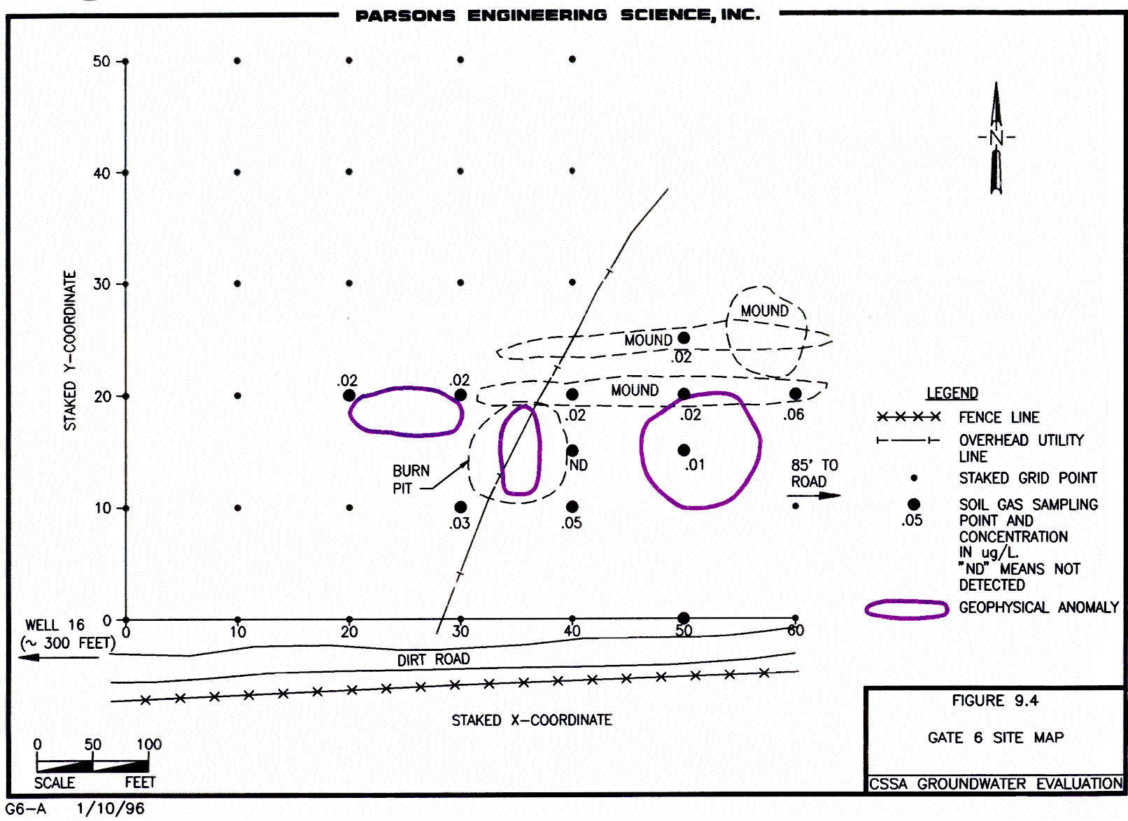
The Gate 6 area is located in North Pasture northwest of gate 6. The site is bounded by a fence line to the south and by trees to the north and west. Also present on the site are a drainage ditch to the south, a power line and burn pit in the central portion of the site, and a dirt mound to the east (Figure 9.4).
PCE was the only target compound detected in soil gas samples from Gate 6. The soil gas survey data are presented in Table 9.1. Samples were collected at a depth of 4 feet. The highest level of tetrachloroethene detected was 0.07 ug/L and occurred at location 50,0 located on the southern edge of the site. No soil gas anomalies exceeding 0.10 ug/L were present at Gate 6. Consequently, no additional sampling was considered necessary at this site during the second phase of the soil gas investigation.
The Salado Creek site is located south of SWMUs B-28 and B-19 and west of SWMU B-4. The site is bounded by trees and SWMU B-4 to the east, B-28 and B-19 to the north, and Salado Creek to the west. The site is relatively clear except for a few scattered trees and a wood pile. Soil gas results are shown on the PCE summary map (Figure 5.3-2).
PCE was detected in soil gas samples from this site during the reconnaissance survey. Additional samples were collected from this site during the second phase of the investigation to define the extent of contamination. A complete listing of the soil gas survey results for the reconnaissance phase is given in Table 9.1 and for the follow-up survey in Table 9.2. Soil gas samples were collected at the soil and bedrock interface or at refusal with sampling depths varying from 1.5 to 8 feet.
In the initial phase, the highest concentration of PCE detected was 0.19 ug/L and was detected at location 0,40. Based on the levels of PCE detected, a distinct source area of PCE does not appear to exist at this site.
In the follow-up phase, PCE was detected at a maximum concentration of 2.0 ug/L at location 0,-10. The occurrence of PCE in the area immediately south of the Salado Creek site could reflect migration of PCE contamination from Oxidation Pond. The lower concentrations beneath Salado Creek site could be due to a geologic barrier, such as clay blocking the migration of PCE into the shallow subsurface. Low permeability areas were observed in Salado Creek and B-4A areas.
9.6 - Area Between B-3 and B-4
This area is long the road between SWMU B-3 on the north and SWMU B-4 on the south, extends into the wooded area on the east, and borders B-28, and B-19 to the west.
During the reconnaissance survey, PCE was the only target compound detected in soil gas samples from the area between SWMUs B-3 and B-4. Following the initial reconnaissance of the area in phase 1, the B-3 grid was extended over the area between B-3 and the oxidation pond. The reconnaissance survey data are presented in Table 9.1 with the follow-up data presented in Table 9.2. Soil gas samples were collected at the bedrock soil interface or at the depth of refusal.
During the initial reconnaissance of the area, the highest concentration of PCE detected was 6.1 ug/L and occurred at location 1,1 which is approximately 100 feet south of B-3. PCE data from the second phase is plotted on Figure 9.5. The data shows that PCE occurs between the oxidation pond and SWMU B-3. A preferred migration pathway, such as a solution feature, may exist between the two sites.
In the initial survey, carbon tetrachloride and chloroform were detected in many of the samples. Based on peak height on the chromatogram, the highest concentrations of carbon tetrachloride and chloroform occurred at location 1,2. In the second phase, carbon tetrachloride was quantified for this area and a maximum concentration of 11 ug/L was detected at location G,13 which was the same as location 1,2 in the initial survey. The carbon tetrachloride may have been in fire fighting foams used to extinguish a fire that occurred near an incinerator located between B-3 and the oxidation pond (B. Murphy, personal communication).