[Home]
[RFI/Closure Report] [Next Section]
SWMU B-23A RCRA Facility Investigation/Closure
Report
Section 1 - Introduction
On May 5, 1999
an Administrative Consent Order was issued to Camp Stanley Storage Activity (CSSA)
pursuant to §3008(h) of the Solid Waste Disposal Act (SWDA), as amended by
Resource Conservation and Recovery Act (RCRA), and further amended by the
Hazardous and Solid Waste Amendments (HSWA) of 1984. In accordance with the RCRA Facility Investigation (RFI) requirements of the Consent Order, an RFI
report for Solid Waste Management Unit (SWMU) B‑23A was completed in July 2003. The purpose of the RFI report was to document the environmental condition of the
site, site closure requirements, and recommend further investigation or provide
documentation necessary for site closure. This closure report includes by
reference the information presented in the SWMU
B‑23A RFI Report.
SWMU B-23A was
a disposal trench, approximately 60 feet by 20 feet by 5 feet deep. Small glass ampueles containing an unknown liquid were visible in the trench surface soil. The SWMU B‑23A RFI Report recommended
excavation and disposal of waste and waste residue. The RFI report estimated
2,420 cubic yards of waste material and residue would require removal at the
site. Results from three surface soil samples collected at SWMU B‑23A indicated
background exceedances of copper. Confirmation sampling for copper and semivolatile organic compounds (SVOC) was to be conducted to confirm that the
site met closure requirements. Copper was the only analyte detected above
background standards during the RFI. SVOC analysis was included due to the
presence of SVOC tentatively identified compounds (TICs) in the liquid in the
ampoules. This report documents the closure activities at SWMU B‑23A.
The closure
work was performed by Parsons under the U.S. Air Force Environmental Remediation
and Construction (ENRAC) Contract F41624-01-D-8544, Task Order 19 (TO 0019). The Air Force Center for Environmental Excellence (AFCEE) provided technical
oversight for the delivery order. Based on the project statement of work (SOW),
a set of work plans to govern the fieldwork was established. These include:
|
Work
Plan Overview |
(Volume 1-1, TO 0019 Addendum); |
|
Site-Specific Work Plan |
(Volume 1-2, SWMU B‑23A); |
|
Field
Sampling Plan |
(Volume 1-4, TO 0019 Addendum); and |
|
Health
and Safety Plan |
(Volume 1-5, TO 0019 Addendum). |
Closure
activities at SWMU B‑23A were conducted during December 2003. As recommended in
the RFI report, excavation and disposal activities were conducted. Excavation
indicated that there was no buried waste material at the site, and only 20 cubic
yards of soil and surface waste was excavated and disposed. Confirmation
sampling was conducted after excavation to verify that the site met closure
requirements.
For this
closure report, Section 1 provides the site-specific background and closure
standard. Section 2 describes the closure actions and closure evaluation. Section 3 summarizes the findings, evaluates attainment of data quality
objectives (DQO), and certifies the site closure. References cited in this
report can be found in the
Bibliography (Volume 1‑1 of the Environmental Encyclopedia).
1.1 - Closure Standard
As described
in
Section 4.3 of the
Risk Assessment Technical Approach Document (Volume 1-6), CSSA opted to
pursue closure of many of its sites under the Risk Reduction Rule (RRR) (30
Texas Administrative Code [TAC] §335). A notification of intent to close sites
identified to date (including SWMU B‑23A) was sent to the Texas Commission on
Environmental Quality (TCEQ) in accordance with the RRR on July 12, 1999. TCEQ
acceptance of this notification was received on October 5, 1999.
Following RRR
guidelines, if site concentrations are at or below background and all waste and
waste residue has been removed, then the site can be closed under Risk Reduction
Standard 1 (RRS1). Background levels are the RRS1 criteria for metals
concentrations, and laboratory reporting limits (RL) are the RRS1 criteria for
organic compounds. Based on the RFI sampling results at SWMU B‑23A, CSSA opted
to clean the site to background levels and pursue closure under RRS1. If
closure requirements under RRS1 are attained and approved by the TCEQ Executive
Director, then the owner is released from the deed recordation requirement.
Due to the
presence of waste at the site, as well as copper concentrations above background
levels, removal of waste and waste residue was recommended to meet RRS1
requirements.
1.2 - Background
and Site Description
1.2.1 CSSA
General
information regarding the history and environmental setting of CSSA is provided
in the CSSA Environmental Encyclopedia (Volume
1-1, Background Information Report). In that report, detailed data
regarding the geology, hydrology, and physiography are also available for
reference.
1.2.2 SWMU B‑23A
1.2.2.1 Site Description
The site
covers approximately 0.3 acre, and is shown in Figure
B23A-6 (Figures B23A‑1
through B23A-5 are provided in the
SWMU B-23A RFI Report). An apparent
trench or disturbed area was observed in a 1966 aerial photograph.
Figure B23A-7 shows aerial photos of the site
over time. A September 1993 field survey revealed a possible trench that
had been filled in with soil. During the field survey, several glass
ampoules containing different colored liquids were discovered on the ground
surface at the site. CSSA did not know exact dates of usage for SWMU B‑23A
or how long the ampoules had been at the site.
Additional
background information regarding the location, size, and known historical
use of the site is also included in the Environmental Encyclopedia (Volume
1-2, SWMU B‑23A). Volume 1-2 includes a Chronology of Actions and a
Site-Specific Work Plan Addendum for SWMU B‑23A.
1.2.2.2 Potential Sources of
Contamination
SWMU B‑23A was presumed to be an in-filled trench during the initial field
survey in September 1993. Several small (½-inch length, ¼-inch diameter)
ampoules, which were determined to be time-delay fuses for M34 delay firing
devices, were present on the ground surface during the site survey. The
ampoules contained liquids of various colors, which correspond to different
delay periods. The liquid contained in the ampoules is a potential
contamination source.
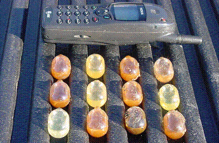
Ampoules found on the ground surface at B-23A. September 2001
Initially,
during the RFI, contaminants of concern (COCs) consisted of metals, volatile
organic compounds (VOC), and SVOCs. Based on the results of the RFI,
including ampoule testing, COCs for closure include copper and SVOCs.
1.2.2.3 Site Location
SWMU B‑23A
is located in the North Pasture of CSSA, approximately 3,200 feet east of
the western boundary of CSSA and approximately 3,000 feet south of the
northern border of CSSA, as shown in Figure B23A-6. SWMU B‑23A is approximately 75 feet long and 30 feet wide. The site’s total
area is approximately 0.3 acre. SWMU B‑23A is located approximately
250 feet southeast of SWMU B-23 and approximately 1,000 feet northeast of
SWMU B-6.
1.3 - Site Environmental Setting
A detailed description of the site environmental setting is
provided in the CSSA
Background information Report (Volume 1-1) and the
SWMU B‑23A RFI Report
(Parsons, 2002).
1.3.1 Site Soil
and Topography
The only soil type occurring at SWMU B‑23A is the Tarrant
Association (Figure B23A‑2 in the
B‑23A RFI Report). Tarrant soil occurs along
the outer edges of the Salado Creek floodplain. The topographic elevation of
the site area varies from approximately 1,320 to 1,330 feet above mean sea level
(MSL). Drainage within SWMU B‑23A is to the west-southwest.
1.3.2 Geology
The Upper Glen Rose (UGR) Limestone is the uppermost
geologic stratum in the area of SWMU B‑23A (Figure B23A-8),
but no bedrock outcrops are present within the site area. The UGR consists of
beds of blue shale, limestone, and marly limestone, with occasional gypsum beds,
up to 50 feet thick. The UGR is underlain by the Lower Glen Rose (LGR)
(approximately 320 feet thick). The LGR Limestone is underlain by the Bexar
Shale (regionally known as Hensell Shale, with an average thickness of
60 feet). The geologic strata at CSSA dip approximately 10 to 12 degrees to the
south-southeast.
1.3.3 Hydrology
The uppermost hydrogeologic layer at CSSA is the unconfined
Upper Trinity Aquifer, which consists of the UGR Limestone. Locally at CSSA,
low-yielding perched zones of groundwater can exist in the UGR. Principal
recharge into the Middle Trinity Aquifer is via precipitation infiltration at
outcrops. Groundwater discharge occurs predominantly via natural springs,
seeps, and pumping. Regional groundwater flow appears to be to the southeast.
No site-specific information regarding groundwater is
available. The nearest well is CS‑MWG-LGR (formerly Well G), which is a
livestock well located approximately 1,000 feet west of SWMU B‑23A (Figure
B23A-2 in the B-23A RFI Report). Static water levels in CS-MWG-LGR have measured between a high of 171.22 feet
bgs (April 2003) and a low of 310.10 feet bgs (September 2000).
1.3.4 Cultural
Resources
Cultural resources are prehistoric
and historic sites, structures, districts, artifacts, or any other physical
evidence of human activity considered important to a culture, subculture, or
community for scientific, traditional, or religious purposes. The nearest
historical cultural resource consists of a burned rock midden located
approximately 750 feet west of SWMU B‑23A.
1.3.5 Potential
Receptors
A survey of local and possible future uses of groundwater
and surface water, water wells, and sensitive environmental areas at CSSA was
completed in December 1999. Results of that survey, along with results from a
more in-depth survey to identify potential receptors, points of human exposure,
and possible constituent pathways, are presented in
Section 3 of the
Technical Approach Document for Risk Evaluation
(Volume 1-6).
The closest sensitive receptor to SWMU B‑23A is the
intermittent creek that lies approximately 750 feet south of the site. Other
nearby receptors include livestock well CS‑MWG-LGR located approximately
1,000 feet west of SWMU B‑23A, and the “DZ” Tank, located approximately
2,500 feet west of the site area. The nearest potential habitats for local
endangered species are approximately 2,000 feet south (Black-capped vireo) and
400 feet east (Golden-cheeked warbler) of SWMU B‑23A (Parsons, 1993). More
detailed information on potential receptors at SWMU B‑23A is included in the
SWMU B‑23A RFI Report
(Parsons, 2003).
1.4 - Previous Investigations
1.4.1 Geophysical Survey
An electromagnetic (EM) geophysical survey was performed at
SWMU B‑23A in March 1995. The EM survey was conducted along northwest-southeast
transects spaced at 20-foot intervals. Neither conductivity nor in-phase EM
data revealed any subsurface anomalies at SWMU B‑23A; therefore, the geophysical
survey results do not indicate the presence of subsurface anomalies potentially
related to past waste management activities. Results of the 1995 geophysical
survey are also provided in
Section 4 of the
Technical Memorandum on Surface Geophysical Surveys at High Priority SWMUs
(Parsons ES, October 1995).
1.4.2 Soil Gas
Survey
A soil gas survey was performed at CSSA in August 1996 in
an effort to identify possible source areas for the chlorinated hydrocarbon
contamination present in the groundwater at well CS-MW16-LGR and other CSSA
wells. Ten soil gas samples were collected within the March 1995 geophysical
grid area and were analyzed for VOCs.
Toluene was detected at 0.4 micrograms/liter (µg/L) in one
soil gas sample (sample point #4) located along the northern side of the
geophysical grid (Figure B23A‑9). VOCs were not
detected in any other samples. Results of the soil gas survey are provided in
the SWMU B‑23A RFI Report (Parsons, 2003).
1.4.3 Surface
Soil Sampling
On January 23, 2003, three surface soil samples were
collected at SWMU B-23A (Figure B23A-4). The surface samples were analyzed for VOCs, SVOCs, and metals. The
samples were collected approximately on the centerline of the in-filled trench.
As shown in Table B23A-1,
no VOCs or SVOCs were detected in surface soils above RRS1 levels. However,
copper slightly exceeded RRS1 in sample CS-B23A-1, which had a reported
concentration of 40.82 milligrams per kilogram (mg/kg) for copper. The
background value for copper in CSSA soil is 23.2 mg/kg.
1.4.4 Ampoule
Sampling
In September 2001, CSSA personnel collected five
different-colored ampoules from the ground surface and submitted them for
analysis at the USEPA Region 6 Environmental Services Branch Laboratory,
Houston, Texas. The ampoule colors were green, dark brown, light brown, yellow,
and clear. In January 2003, Parsons personnel collected an additional two
ampoules from SWMU B-23A. The additional ampoules were orange and yellow in
color. The two ampoules were sent to APPL Laboratory in Fresno, California for
analysis.
Results from both sample sets provided only TICs. Some
examples of TICs are benzaldehyde, hexadeanoic acid, and taraxerol methyl
ester. Laboratory equipment cannot be calibrated to reliably quantify the
analytes listed as TICs because no calibration curve has been established for
these compounds; therefore, RLs and method detection limits (MDL) are not
available for those analytes. An analytical results summary is provided in
Appendix A of the
SWMU B-23A RFI Report.
[Next Section]